The Dempster Highway was originally conceived of in 1958 as an
all-season overland link between the Arctic and southern Canada, but
political wrangling and high costs left the project less than a quarter
finished when it was abandoned in 1961. It resumed again in 1968 when
oil was discovered at Prudhoe Bay in Alaska, and was completed and
opened to the public in 1979. At the time it was the only road into the
Arctic Circle in North America; only when the Alaska Pipeline Haul Road
(the Dalton Highway) was opened to the public in 1998 did it have any
equal.
View Larger Map
I'd actually ridden the Dalton Highway to Prudhoe Bay four years ago, during the summer of 2009. I was on a '97 Yamaha Virago 750 then; my very first bike quite possibly the least appropriate motorcycle conceivable for the journey. Now I was at the start another similar road, armed with vastly more riding experience and a bike that was much better suited to the task of a 500 mile long unpaved path through some of the most desolate places on earth.

As is usual, you're greeted by a slew of warning signs as you start off. You're on your own up here; do your best not to crash. It's a long way to anywhere.


The Dempster is only paved for the first half mile, and after that it's all clay and gravel.


Clay, gravel, and spectacular scenery and weather. Most of the road was pretty manageable, but there were long stretches of softball-sized rocks embedded the clay. It's atrociously rough to ride over, but it does give much firmer and more predictable traction than the loose gravel.

Bear!


Seventy-odd miles up the Highway you come to the Tombstone visitor center, the hub of Tombstone Regional Park.


It's your fairly standard park service exhibit center; displays and information on the history of the area and the Dempster highway, the native people, plants and animals. And of course, the shoes-off policy.


Apparently they'd had a book signing earlier that day, and leftover from that event were platters of snack food. I completely demolished everything that was left on them, as it meant one less meal I have to pay for or cook myself.

Out from the visitor's center I went, riding north and up into the mountains.


So far this day, the weather had been perfect; somewhere in the 60s, mostly sunny and breezy. As I climbed higher in elevation it seemed less likely that this would last, and all the clouds ahead were looking increasingly ominous.


I ran into the first squall line about an hour after leaving the visitor center, and much of the rest of the day was spend picking my way through rough and sloppy patches of mud. The only upside was that the rain was intermittent enough that I never got soaked completely through, there were long enough periods of not-rain that I could dry out a bit in between showers.
The road was wet and muddy, but passable. You learn quickly that you often want to aim for what looks to be the wetter sections of gravel; a slick of standing water on the surface means the dirt under is likely harder-packed and non-porous. The stuff that looks dry is usually loose and falls apart under the wheels, leading to a number of OH SHIT I'M GOING SIDEWAYS moments.


I started looking for someplace to camp around . . . eh, probably 10pm, although this far north it doesn't matter much. I pulled into a large parking area that looked like it was sometimes used to stage gravel and other road building materials, or perhaps a storage location for road equipment.

Initially I found it too exposed and close to the road for my tastes, but as I wandered around the back side of the lot I found a small path heading up the hill, to the top of the ridge line.

Going up here yielded even more spectacular views and while it was still open, it left me hidden from the road and had enough breeze to keep any bugs away.


On the northern edge of the clearing was a large section of loose rock, that apparently many people over the years had taken to making piles of them. It was an oddly primitive yet very human touch in an extremely desolate place; I read somewhere once that the Inuit and Native Americans used simple structures like these to mark safe places to rest. I doubted any of these were that old, but I couldn't have had a better indication that this was a good place to camp for the night. Sitting among the small pillars of loose stone, listening to the breeze and looking out over the valley, here I was as content with the world as I've ever been.


The next day dawned (as much as it could dawn, it never really got dark) with similar weather as the prior day; cool and damp, with a cloud bank moving through the valley I was to ride into.

Only a few miles down the road I found yet another tourist info platform, with more information about the history of the local area. There were actually a lot of these along the route, and they didn't feel as out-of-place as they had along the Dalton Highway in Alaska.

For the time being I'd left most of the rain behind; the road was dry and solid, with easily visible sections of loose gravel that could be avoided without problems.


At least it WAS dry and solid, until I came around the corner at a decent clip to be greeted with six inches of fresh lose dirt. After slaloming wildly through it for a hundred feet I managed to get the bike over to one tiny section that was still hard-packed, so I could stop and snapped a picture while I wanted for the adrenalin buzz of OH GOD I ALMOST DIED to wear off.

A small fleet of trucks were accompanied by a couple of graders, and they were dumping loads of fresh dirt onto the road. Over the next couple weeks I had no doubt the rain and traffic would pack it down to a ride-able surface, but as it sat it was a disaster. It was loose and offered almost no grip; the front wheel acting more like a rudder than a wheel and the back tire couldn't even get enough grip to throw up a rooster tail. The next hour of riding was spent picking through this stuff at 10mph, desperately searching out the harder-packed lines that might offer some purchase.

I made it out of the sloppy stuff after quite a few experiences of almost dropping the bike, but going back to firm dry clay brought back another favorite of motorcyclists everywhere; enormous dust clouds from passing trucks.

These were pretty frequent as I went farther north; not much besides a windsock at one end and some orange markers at thousand foot intervals, but that's enough to turn a road into an airstrip.


The weather cleared up the farther north I went, and after a few more hours of not-too-bad roads I made it to roughly the half-way point of the highway; Eagle Plains

Eagle Plains is little more than a glorified truck stop; it offers fuel, a restaurant and lodging at fairly high prices, not not much else. Enjoyably, the entrance to the little service shack was adorned with stickers from various motorcycle clubs.
And inside they had a reminded of why regular chain and sprocket maintenance is a good thing.

I got gas and lunch at the little restaurant there, and kept on pushing north.

I was greeted with fair sky and clear weather when an hour later, I officially entered the Arctic Circle.

Gratuitous selfie!

It's hard to believe someplace this beautiful and tranquil can have winters that are so harsh.

Farther north I went, up into another mountain range.


Higher and higher the road went, closer to the clouds until eventually I was in them.


Up here, in this cloud bank, well above the tree line, this was what I had wanted the Arctic to be. It was cold, it was barren, it was desolate and empty. I shut off the bike and the only sound I could hear was the wind, blowing the ever-shifting clouds across my path.
This place was perfect.

I crossed the border into the Northwest Territories a couple hours after getting into the Circle. Sadly, even this far away from the developed world, lazy people have had their effect. :(
On and on the fog went.

The border of the Northwest Territories and the Yukon is the crest of this mountain range; after passing over it, I started dropping in altitude and lost the clouds.

Well that's . . . odd.

I wonder what happened here? I can't imagine it was here long, is random vandalism that much of a problem that your windows will get shattered if you leave your car alone here for a while?

Onward and northward, with more tourist info stations along the way. I was dropping quickly out of the mountains and the terrain flattened out rapidly as I got into the Mackenzie River Delta.


Back down here at lower altitudes the trees began to re-appear, and there were even more touches of civilization. This is an all-season road and in the winter it's cold enough for vehicles of all weights to drive across the frozen river; there's no sense in having a bridge. Numerous crossings are dealt with by free ferries.

There was still the better part of 150 miles to go before I'd get to Inuvik at the end of the highway, but all the interesting geography and terrain had vanished. Almost everything here was flat and straight, with only the occasional bend to differentiate one places from another. Endlessly repetitive trees, clouds and dirt, for hours on end.

I rode for another few hours, making it to within 60 miles of Inuvik before calling it a day. It was fairly late by that point and I didn't think anything in the town would be open by the time I got there, so I pulled into a dis-used gravel quarry and went to sleep for the night.

I awoke the next day to a light, cold rain; it was in the 40s and everything was wet. The only blessing was that the rain wasn't heavy; just the ongoing light sprinkle, enough to keep your visor clean and the dust down if I have to be optimistic about it. The rain showers were sporadic for the whole morning, occasionally clearing up for patches of blue sky before returning.

I rolled into the town in the middle of the day, unsure of what to expect. My prior experience with people living this far north had been when I went to Prudhoe Bay back in 2009, and that was just a work camp. Inuvik, by contrast, is an actual town where people live.


Much to my chagrin, even someplace this remote hasn't been able to avoid being tainted by the most wretched, miserable, bland, horrible, boring, ridiculously stupid excuse for a sport the world has seen; even up here, they still have golf.
My
first stop, as is usual when I pass through any of these towns, was the
tourist info center. It was a nice place, but fairly typical; it had
some information and exhibits on the local culture and history, which
recently has focused heavily on mining and oil drilling (hence the
chromed bit head).


I hadn't planned on spending much time in the town; ride in, grab some stickers, get gas and ride out. I had a schedule to keep, and all. But my schedule didn't account for the girl working at the tourist info center to be one of the most beautiful women that I've ever seen.
And I don't mean the usual levels of "Oh, she's really pretty." Many of my friends are professional models and I've done some modeling myself, I'm used to being around exceedingly good looking people. But this girl knocked me off my feet. Perhaps it's my well established weakness for tall, willowy redheads, or maybe it's all retrospective after she and I spent the entire rest of the day (and even another two hours after the center closed) immersed in conversation, but I can count the number of times I've met people like her on my fingers and still end up with a few left over. It was almost 10pm by the time we decided we had to tear our brains apart; emails addresses were exchanged as were promises to stay in touch.
I find it odd that I have to go to the literal ends of the earth to find people like that.
View Larger Map
I'd actually ridden the Dalton Highway to Prudhoe Bay four years ago, during the summer of 2009. I was on a '97 Yamaha Virago 750 then; my very first bike quite possibly the least appropriate motorcycle conceivable for the journey. Now I was at the start another similar road, armed with vastly more riding experience and a bike that was much better suited to the task of a 500 mile long unpaved path through some of the most desolate places on earth.

As is usual, you're greeted by a slew of warning signs as you start off. You're on your own up here; do your best not to crash. It's a long way to anywhere.


The Dempster is only paved for the first half mile, and after that it's all clay and gravel.


Clay, gravel, and spectacular scenery and weather. Most of the road was pretty manageable, but there were long stretches of softball-sized rocks embedded the clay. It's atrociously rough to ride over, but it does give much firmer and more predictable traction than the loose gravel.

Bear!


Seventy-odd miles up the Highway you come to the Tombstone visitor center, the hub of Tombstone Regional Park.


It's your fairly standard park service exhibit center; displays and information on the history of the area and the Dempster highway, the native people, plants and animals. And of course, the shoes-off policy.


Apparently they'd had a book signing earlier that day, and leftover from that event were platters of snack food. I completely demolished everything that was left on them, as it meant one less meal I have to pay for or cook myself.

Out from the visitor's center I went, riding north and up into the mountains.


So far this day, the weather had been perfect; somewhere in the 60s, mostly sunny and breezy. As I climbed higher in elevation it seemed less likely that this would last, and all the clouds ahead were looking increasingly ominous.


I ran into the first squall line about an hour after leaving the visitor center, and much of the rest of the day was spend picking my way through rough and sloppy patches of mud. The only upside was that the rain was intermittent enough that I never got soaked completely through, there were long enough periods of not-rain that I could dry out a bit in between showers.
The road was wet and muddy, but passable. You learn quickly that you often want to aim for what looks to be the wetter sections of gravel; a slick of standing water on the surface means the dirt under is likely harder-packed and non-porous. The stuff that looks dry is usually loose and falls apart under the wheels, leading to a number of OH SHIT I'M GOING SIDEWAYS moments.


I started looking for someplace to camp around . . . eh, probably 10pm, although this far north it doesn't matter much. I pulled into a large parking area that looked like it was sometimes used to stage gravel and other road building materials, or perhaps a storage location for road equipment.

Initially I found it too exposed and close to the road for my tastes, but as I wandered around the back side of the lot I found a small path heading up the hill, to the top of the ridge line.

Going up here yielded even more spectacular views and while it was still open, it left me hidden from the road and had enough breeze to keep any bugs away.


On the northern edge of the clearing was a large section of loose rock, that apparently many people over the years had taken to making piles of them. It was an oddly primitive yet very human touch in an extremely desolate place; I read somewhere once that the Inuit and Native Americans used simple structures like these to mark safe places to rest. I doubted any of these were that old, but I couldn't have had a better indication that this was a good place to camp for the night. Sitting among the small pillars of loose stone, listening to the breeze and looking out over the valley, here I was as content with the world as I've ever been.


The next day dawned (as much as it could dawn, it never really got dark) with similar weather as the prior day; cool and damp, with a cloud bank moving through the valley I was to ride into.

Only a few miles down the road I found yet another tourist info platform, with more information about the history of the local area. There were actually a lot of these along the route, and they didn't feel as out-of-place as they had along the Dalton Highway in Alaska.

For the time being I'd left most of the rain behind; the road was dry and solid, with easily visible sections of loose gravel that could be avoided without problems.


At least it WAS dry and solid, until I came around the corner at a decent clip to be greeted with six inches of fresh lose dirt. After slaloming wildly through it for a hundred feet I managed to get the bike over to one tiny section that was still hard-packed, so I could stop and snapped a picture while I wanted for the adrenalin buzz of OH GOD I ALMOST DIED to wear off.

A small fleet of trucks were accompanied by a couple of graders, and they were dumping loads of fresh dirt onto the road. Over the next couple weeks I had no doubt the rain and traffic would pack it down to a ride-able surface, but as it sat it was a disaster. It was loose and offered almost no grip; the front wheel acting more like a rudder than a wheel and the back tire couldn't even get enough grip to throw up a rooster tail. The next hour of riding was spent picking through this stuff at 10mph, desperately searching out the harder-packed lines that might offer some purchase.

I made it out of the sloppy stuff after quite a few experiences of almost dropping the bike, but going back to firm dry clay brought back another favorite of motorcyclists everywhere; enormous dust clouds from passing trucks.

These were pretty frequent as I went farther north; not much besides a windsock at one end and some orange markers at thousand foot intervals, but that's enough to turn a road into an airstrip.


The weather cleared up the farther north I went, and after a few more hours of not-too-bad roads I made it to roughly the half-way point of the highway; Eagle Plains

Eagle Plains is little more than a glorified truck stop; it offers fuel, a restaurant and lodging at fairly high prices, not not much else. Enjoyably, the entrance to the little service shack was adorned with stickers from various motorcycle clubs.
 |
| It's a special breed of people who's idea of a nice vacation is to ride their motorcycle into the most far-off lands they can find. |
And inside they had a reminded of why regular chain and sprocket maintenance is a good thing.

I got gas and lunch at the little restaurant there, and kept on pushing north.

I was greeted with fair sky and clear weather when an hour later, I officially entered the Arctic Circle.
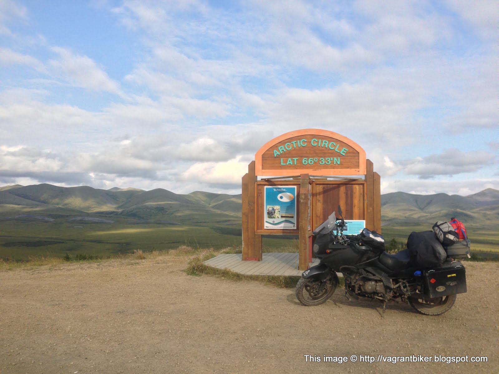
Gratuitous selfie!

It's hard to believe someplace this beautiful and tranquil can have winters that are so harsh.

Farther north I went, up into another mountain range.


Higher and higher the road went, closer to the clouds until eventually I was in them.


Up here, in this cloud bank, well above the tree line, this was what I had wanted the Arctic to be. It was cold, it was barren, it was desolate and empty. I shut off the bike and the only sound I could hear was the wind, blowing the ever-shifting clouds across my path.
This place was perfect.

I crossed the border into the Northwest Territories a couple hours after getting into the Circle. Sadly, even this far away from the developed world, lazy people have had their effect. :(
 |
| Not all shitty beer drinkers are assholes, but I'm pretty sure all assholes drink shitty beer. |
On and on the fog went.

The border of the Northwest Territories and the Yukon is the crest of this mountain range; after passing over it, I started dropping in altitude and lost the clouds.

Well that's . . . odd.

I wonder what happened here? I can't imagine it was here long, is random vandalism that much of a problem that your windows will get shattered if you leave your car alone here for a while?

Onward and northward, with more tourist info stations along the way. I was dropping quickly out of the mountains and the terrain flattened out rapidly as I got into the Mackenzie River Delta.


Back down here at lower altitudes the trees began to re-appear, and there were even more touches of civilization. This is an all-season road and in the winter it's cold enough for vehicles of all weights to drive across the frozen river; there's no sense in having a bridge. Numerous crossings are dealt with by free ferries.

There was still the better part of 150 miles to go before I'd get to Inuvik at the end of the highway, but all the interesting geography and terrain had vanished. Almost everything here was flat and straight, with only the occasional bend to differentiate one places from another. Endlessly repetitive trees, clouds and dirt, for hours on end.

I rode for another few hours, making it to within 60 miles of Inuvik before calling it a day. It was fairly late by that point and I didn't think anything in the town would be open by the time I got there, so I pulled into a dis-used gravel quarry and went to sleep for the night.

I awoke the next day to a light, cold rain; it was in the 40s and everything was wet. The only blessing was that the rain wasn't heavy; just the ongoing light sprinkle, enough to keep your visor clean and the dust down if I have to be optimistic about it. The rain showers were sporadic for the whole morning, occasionally clearing up for patches of blue sky before returning.

I rolled into the town in the middle of the day, unsure of what to expect. My prior experience with people living this far north had been when I went to Prudhoe Bay back in 2009, and that was just a work camp. Inuvik, by contrast, is an actual town where people live.


Much to my chagrin, even someplace this remote hasn't been able to avoid being tainted by the most wretched, miserable, bland, horrible, boring, ridiculously stupid excuse for a sport the world has seen; even up here, they still have golf.
 |
| IS NO PLACE SAFE FROM THIS SCOURGE OF THE SPORTING WORLD!? |


I hadn't planned on spending much time in the town; ride in, grab some stickers, get gas and ride out. I had a schedule to keep, and all. But my schedule didn't account for the girl working at the tourist info center to be one of the most beautiful women that I've ever seen.
And I don't mean the usual levels of "Oh, she's really pretty." Many of my friends are professional models and I've done some modeling myself, I'm used to being around exceedingly good looking people. But this girl knocked me off my feet. Perhaps it's my well established weakness for tall, willowy redheads, or maybe it's all retrospective after she and I spent the entire rest of the day (and even another two hours after the center closed) immersed in conversation, but I can count the number of times I've met people like her on my fingers and still end up with a few left over. It was almost 10pm by the time we decided we had to tear our brains apart; emails addresses were exchanged as were promises to stay in touch.
I find it odd that I have to go to the literal ends of the earth to find people like that.