I was now in western Newfoundland (Sorry for all my previous incidents of screwing up east and west, I've been on the road too long and the wording part of my brain has gotten melty), with a mostly-repaired motorcycle and a major decision to make. Do I head up through the remoteness of Labrador, or go back south into Nova Scotia?
This was a decision that I had to make because of the cause of all the funny-colored clouds over the last few days; it was all smoke from lots of large forest fires burning in Quebec and Labrador, blowing across the Gulf of St Lawrence and hazing up the whole western part of Newfoundland.

Most specifically, there were many reports of frequent closures of the road link between Labrador City and Goose Bay, which is the ONLY way to get between those cities. There was a real chance that I'd get to Labrador, ride half way across it only to get stuck there, or have to turn around and backtrack down into Newfoundland again; it's not like there's an alternate route across the province that I could take.
Labrador is almost completely uninhabited, save for a few small communities along the coast and the towns of Goose Bay and Labrador City, of 8,000 and 20,000 residents respectively. With such low population densities and a very harsh climate for most of the year, a land link across the province was only just completed in 2011; the final leg of the Trans-Labrador Highway to be completed was a 260 mile stretch between Port Simpson and Goose bay, with no settlements or services for the whole route.
So, did I want to gamble with that? That I might ride halfway across Labrador, only to get stuck there for a few days or be forced to turn around?
I chose yes; mostly because I knew I'd hate myself forever if I did head back down to Nova Scotia, only to hear from other people that the highway had been opened. So I headed out of Corner Brook and headed back north, taking a gravel road up into the hills and camping in a large clearing outside of a logging dump.

One thing that I was going to need if I was heading into Labrador was extra fuel; the largest stretch of the Trans-Lab with out services is over 260 miles. The bike has no problem doing that on pavement, but that section of the road isn't paved, and staying in lower gears at lower speeds can have drastic effects on the fuel economy. While I could theoretically make it on just the main tank, that was right on the margin of error and left me no wiggle room. With that in mind, a quick stop to the hardware store got me another few gallons of capacity; more than I'd need.

Heading back east for a bit, I took the turn off at Deer Lake and pointed the bike north, through Gros Morne National Park.

Pretty, but very hazy.


As I headed farther north up Newfoundland, it got much clearer, but much harsher. This area is almost constantly battered by sea winds coming off the gulf, and the few trees are stunted and bent over with the wind. Even in July it was chilly.


It took most of the day to ride north, and I only JUST caught the last ferry of the day at 5pm. Contrary to the highly lucrative tourist trade that inflates the prices of the southern ferries (I paid $230 to get from Nova Scotia, and that was without a cabin), this ferry seems to mostly service people who live and work in the area. And at $12, it was much more reasonable.

The 90 minute crossing deposited me into Blanc-Sablon, which is ever so theoretically in Quebec. Heading East for about two minutes put me into Labrador Proper.


The weather was what I expected and had actually hoped for; mid 50s, overcast, constant threat of drizzle, and relentless 30mph winds. Here as well, the few little settlements gave the distinct impression of working very hard to survive in a climate that frequently isn't accommodating.

While I was fully prepared to find someplace to camp that night, I gave into the promise of a sign for a B&B that advertised free Internet. Even though I know it's just what B&Bs are, and it's how they work, the idea of just staying in a complete strangers house is totally weird to me (as nice as it was, and especially reasonably priced for this part of the world). A hotel would have likely been twice as much, if there had even been one.

(A note for hotel or accommodation owners; if you hope to attract anyone under the age of 35, you are EXPECTED to provide internet access. And if you do, you need to advertise it front and center. To almost everyone of my generation, internet is FAR more critical than cable TV in the room)

Being inside and having an actual shower also gave me a chance to take stock of how my injuries from the bike crash were doing. My shoulder was looking much better than it had been.

The next day, well rested and cleaned, I headed northwest, on what's basically the only road out of town. It's paved for a while, and the weather wasn't looking promising; I wasn't sure if it was rain/fog, or smoke.

For a while it seemed like it was just going to be smoke, which I preferred over the alternative. Soon the pavement ran out, and a slew of warning signs marked the start of the Trans-Lab highway, heading into the interior.

This is a harsh climate; like many sub-arctic areas, it's clear that the things living here are doing so only out of tenacity and stubbornness. It's cold, it's windy, it's barren and it makes you very clear of the fact that you're alive in someplace that you probably shouldn't be.


The road was okay. Not great, but okay. There were some long sections of washboarding, but it was wide enough that sometimes I could find a smoother line and most of the lose gravel hand been pushed aside, leaving only thing layer of small rocks over a hard packed clay, with large rocks embedded in it. It was rough, quite rough, but if you were paying attention 40mph+ was reasonable for most of it.

Gradually, the haze from the fires to the west began to look . . . different. More solid, more stratified by elevation.

Rain. Cold, hard rain.

The rain softened up the road a bit; now the washboarding was much more extensive, and far longer lasting. Strangely I found myself often aiming for the small piles of gravel; it might make the bike dance around some, but at least it was usually smoother.
The farther I went, the harder the rain came down and the softer the road got.

Anyone who's been in this before knows how miserable it is. You keep yourself going mentally by promising yourself that just over the next curve you'll see blue sky, that it'll just about to lighten up. Because if you admit to yourself that you're going to be in this crap for the next six hours, it's hard to find the motivation to keep going.
As I rode along, I had to keep reminding myself that this was what I wanted. This was what I'd been dreaming about, months ago in the planning stages; a desolate and destroyed mud road through impossibly remote and uninhabited areas. The black flies and mosquitoes that get up inside your helmet the instant you stop riding. The cold, the wind, the unpredictable weather and unforgiving road, for hours on end, with no alternative. I had specifically asked for this. Why else would I have come to Labrador? Why else would one tour through these areas if not to experience the worst that motorcycling has to offer.
We're a masochistic bunch, we are.

I'm not sure what it was for, but at one point I came across a small helicopter idling in a clearing on the side of the road. In the time it took me to pull out the camera, he'd lifted off and was on his way. There were no military markings on the side of it, only a red maple leaf and the wording "Canadian Chiropractors".

This mud went on for hours and hours, finally bringing me to the junction town of Port Simpson. It's similar enough to the other small communities I'd ridden through earlier; small houses and a general store, couple signs advertising B&Bs. I'm not sure what economic forces birthed these towns in the first place, but I got the sense that they're not doing well now.
I stopped in at the gas station, topping off the bike's main tank as well as filling the red jerry cans.

The parking lot was a minefield of puddles of questionable depth, slippery areas, and soft mud. I couldn't put the bike on the kickstand next to the pump, and I had to drive around for a couple of minutes before I found somewhere solid enough to park the bike, so I could go in and pay.

I seriously considered throwing in the towel for the day; perhaps the B&Bs here would be as reasonable as the one further south had been. The prospect of being dry and warm sounded amazing, and I really didn't want to have to set up camp in this; due to the design of the tent, it's impossible to set it up in the rain without getting the inside wet. Based on little more than a coin flip, I said to hell with it and rode out of town; I didn't feel like spending any more money, and I was already cold and wet. Might as well get the rest over with, and deal with another twelve hours of mud, through some even more desolate areas.

And some day in my future, I would get my twelve more hours of mud. I would get more borderline hypothermia, 45 degrees with 30mph wind blowing water up under the chinbar of the helmet. More of the visor AND glasses fogging up, making it impossible to see anything until you get lucky and a bead of condensation runs down the inside, giving you a tiny little window to avoid potholes with.
But today was not that day; less than twenty minutes outside of town, this happened.

And then this happened.


It was JOYFUL. This road is much newer, only completed in 2011, and was very smooth. Some sections I was in 6th gear doing full highway speeds without worry, blasting along and letting the mercifully warm, dry air suck the moisture out of me.
Being dry did have downsides; while I could see where I was going and I wasn't hating the world, passing the trucks was a fun exercise in OH GOD WHERE DID THE WORLD GO.


I made camp that night in a dis-used rock quarry; the road getting there wasn't too bad, but taking the service road up the size was sketchy. There was only a two-foot section that I could get through in some areas, and the penalty for getting it wrong was a 30 foot drop to the floor.
But once I was up there, I found it to be open enough that a good breeze kept the bugs down, and then I turned around and saw the view.

Evidently, I wasn't the only motorcycle that thought this was a good camping spot; I'd passed a BMW 1200GSA earlier in the day, coming the other direction; were these his tire tracks? Looks like TCK80s to me.

My lower legs had been sort of itching all day; it hadn't been enough to make me stop and investigate, and with the weather I'd had more pressing things on my mind, but as I undressed in my tent this night I checked them out. The first thing I noticed was the pants on my shins were covered in tiny little dots of dried blood; WTF?


I counted a total of 26 bites of an unknown origin, all confined purely to my shins and calves; nothing was above the knee. And of course now that I saw them, they ALL itched to high heaven, and I think I used half my tube of benzocain to try and get them to shut up so I could sleep this night. How had this happened? Had the B&B that I stayed at had some kind of insect infestation, that managed to get into my boots and bike through my windproof suit liner, and pants? Ugh.

By the next morning they had all swollen up so badly that I had to let my boot straps out another couple of notches just so I could get them fastened, and the itching was even worse. Stupid nature.
Anyway, the weather the next day was even more perfect than the previous evening, and I made good time. It started getting washboarded a bit more the closer I got to Goose Bay, but I could still keep the speed high enough that 5th and 6th gear were usable.

Just before getting to Goose Bay, the Churchill River is traversed via a quarter-mile long bridge. Being this exposed to the wind was sobering, and more than once I almost found myself getting blown into the supports. The wind was whipping up massive dust clouds from the settled silt areas, as well.


I made it into town with less than half a gallon of gas left in the main fuel tank, but make it I did. After getting gas, the first thing I did was check the status of the road; was it open? Had my gamble paid off?

YES! I was victorious! Although the warnings about there being no hotel rooms available anywhere along the route made me chuckle. Bitch, please! I bring my own room!
For as remote of a place as it's in, Goose Bay is a pretty normal looking small town, with one key difference. All of the parking spaces, along every building, has a line of 20a outlets for each space. These are for the vehicle block heaters in the winter; this place gets seriously cold.

I stopped at a local fried chicken place for some lunch; as ugly as the bike is, it always seems to draw a crowd. Maybe it's the luggage piled on it, or just all the stickers.
I headed out of town after spending a couple hours at the local library, catching up on the Internet. According to the town's website, as well as the guy manning the roadblock, the road was clear all the way past Churchill Falls, a couple hundred miles east. At some point along the way I'd run into the next roadblock, where I'd have to wait for a police escort to take me and the other vehicles through the areas that were either on fire, or very recently on fire.
With good news and good weather, I headed east.


The road between Goose Bay and Churchill Falls is in the process of being paved; some of it is very fresh and I passed a good number of road crews, but large sections of it are still dirt and gravel.

Likely due to the higher traffic volume, this road was MUCH rougher than the long stretched I'd come north on. The washboarding was much more persistent and often there wasn't a single smooth line through, just mile after mile of endless pounding. Even after backing off the rebound damping nearly all the way on the rear shock, it was still starting to pack down at higher speeds. Not fun, and not what I needed with a rear subframe that is still kinda questionable.

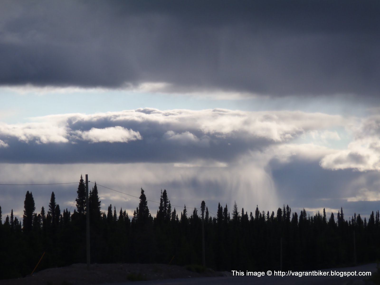
The weather was patchy; for the most part it was a 25mph headwind and patchy sun, but occasionally there'd be a spot of rain. Sometimes it looked like the rain was evaporating before it hit the ground.


Just a few miles before I got to Churchill falls, I turned down a little side road that had all sorts of promising warning signs.


The road ended up being both a service path for the water outlet from a hydroelectric setup, but also a recreational boat launch. Most of the industry in this area is either mining, logging, or timber, and randomly in what you thought was a desolate wilderness, you'll come across a giant cable farm.


I followed a little trail off the side road, eventually ending in a couple of sandy clearings. It was a bit too wooded and closed in for my tastes; not much breeze down here and the flies swarmed the second I stopped.


Getting out of the sandy bits was sketchy; I almost spun out a couple times, but it happened too quickly for me to panic and do something dumb like chop the throttle. So rather than to a half turn\slid and drop it, I ended up doing a couple of bad-ass looking 180s that I pretended were completely intentional (even if they pointed me the wrong way.)
Eventually, I made camp higher up the valley, in a clearing with a nice breeze to keep the flies at bay.

With any luck, the next day would see Labrador City, and I could declare victory on the Trans-Lab! (Of course, I had no idea what Quebec had in store for me...)
This was a decision that I had to make because of the cause of all the funny-colored clouds over the last few days; it was all smoke from lots of large forest fires burning in Quebec and Labrador, blowing across the Gulf of St Lawrence and hazing up the whole western part of Newfoundland.

Most specifically, there were many reports of frequent closures of the road link between Labrador City and Goose Bay, which is the ONLY way to get between those cities. There was a real chance that I'd get to Labrador, ride half way across it only to get stuck there, or have to turn around and backtrack down into Newfoundland again; it's not like there's an alternate route across the province that I could take.
Labrador is almost completely uninhabited, save for a few small communities along the coast and the towns of Goose Bay and Labrador City, of 8,000 and 20,000 residents respectively. With such low population densities and a very harsh climate for most of the year, a land link across the province was only just completed in 2011; the final leg of the Trans-Labrador Highway to be completed was a 260 mile stretch between Port Simpson and Goose bay, with no settlements or services for the whole route.
So, did I want to gamble with that? That I might ride halfway across Labrador, only to get stuck there for a few days or be forced to turn around?
I chose yes; mostly because I knew I'd hate myself forever if I did head back down to Nova Scotia, only to hear from other people that the highway had been opened. So I headed out of Corner Brook and headed back north, taking a gravel road up into the hills and camping in a large clearing outside of a logging dump.

One thing that I was going to need if I was heading into Labrador was extra fuel; the largest stretch of the Trans-Lab with out services is over 260 miles. The bike has no problem doing that on pavement, but that section of the road isn't paved, and staying in lower gears at lower speeds can have drastic effects on the fuel economy. While I could theoretically make it on just the main tank, that was right on the margin of error and left me no wiggle room. With that in mind, a quick stop to the hardware store got me another few gallons of capacity; more than I'd need.

Heading back east for a bit, I took the turn off at Deer Lake and pointed the bike north, through Gros Morne National Park.

Pretty, but very hazy.


As I headed farther north up Newfoundland, it got much clearer, but much harsher. This area is almost constantly battered by sea winds coming off the gulf, and the few trees are stunted and bent over with the wind. Even in July it was chilly.


It took most of the day to ride north, and I only JUST caught the last ferry of the day at 5pm. Contrary to the highly lucrative tourist trade that inflates the prices of the southern ferries (I paid $230 to get from Nova Scotia, and that was without a cabin), this ferry seems to mostly service people who live and work in the area. And at $12, it was much more reasonable.

The 90 minute crossing deposited me into Blanc-Sablon, which is ever so theoretically in Quebec. Heading East for about two minutes put me into Labrador Proper.


The weather was what I expected and had actually hoped for; mid 50s, overcast, constant threat of drizzle, and relentless 30mph winds. Here as well, the few little settlements gave the distinct impression of working very hard to survive in a climate that frequently isn't accommodating.

While I was fully prepared to find someplace to camp that night, I gave into the promise of a sign for a B&B that advertised free Internet. Even though I know it's just what B&Bs are, and it's how they work, the idea of just staying in a complete strangers house is totally weird to me (as nice as it was, and especially reasonably priced for this part of the world). A hotel would have likely been twice as much, if there had even been one.

(A note for hotel or accommodation owners; if you hope to attract anyone under the age of 35, you are EXPECTED to provide internet access. And if you do, you need to advertise it front and center. To almost everyone of my generation, internet is FAR more critical than cable TV in the room)

Being inside and having an actual shower also gave me a chance to take stock of how my injuries from the bike crash were doing. My shoulder was looking much better than it had been.

The next day, well rested and cleaned, I headed northwest, on what's basically the only road out of town. It's paved for a while, and the weather wasn't looking promising; I wasn't sure if it was rain/fog, or smoke.

For a while it seemed like it was just going to be smoke, which I preferred over the alternative. Soon the pavement ran out, and a slew of warning signs marked the start of the Trans-Lab highway, heading into the interior.
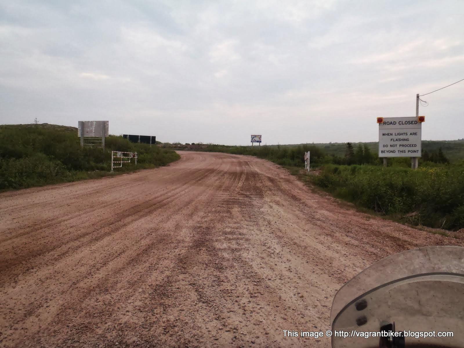
This is a harsh climate; like many sub-arctic areas, it's clear that the things living here are doing so only out of tenacity and stubbornness. It's cold, it's windy, it's barren and it makes you very clear of the fact that you're alive in someplace that you probably shouldn't be.


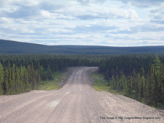
The road was okay. Not great, but okay. There were some long sections of washboarding, but it was wide enough that sometimes I could find a smoother line and most of the lose gravel hand been pushed aside, leaving only thing layer of small rocks over a hard packed clay, with large rocks embedded in it. It was rough, quite rough, but if you were paying attention 40mph+ was reasonable for most of it.

Gradually, the haze from the fires to the west began to look . . . different. More solid, more stratified by elevation.

Rain. Cold, hard rain.

The rain softened up the road a bit; now the washboarding was much more extensive, and far longer lasting. Strangely I found myself often aiming for the small piles of gravel; it might make the bike dance around some, but at least it was usually smoother.
The farther I went, the harder the rain came down and the softer the road got.

Anyone who's been in this before knows how miserable it is. You keep yourself going mentally by promising yourself that just over the next curve you'll see blue sky, that it'll just about to lighten up. Because if you admit to yourself that you're going to be in this crap for the next six hours, it's hard to find the motivation to keep going.
As I rode along, I had to keep reminding myself that this was what I wanted. This was what I'd been dreaming about, months ago in the planning stages; a desolate and destroyed mud road through impossibly remote and uninhabited areas. The black flies and mosquitoes that get up inside your helmet the instant you stop riding. The cold, the wind, the unpredictable weather and unforgiving road, for hours on end, with no alternative. I had specifically asked for this. Why else would I have come to Labrador? Why else would one tour through these areas if not to experience the worst that motorcycling has to offer.
We're a masochistic bunch, we are.

I'm not sure what it was for, but at one point I came across a small helicopter idling in a clearing on the side of the road. In the time it took me to pull out the camera, he'd lifted off and was on his way. There were no military markings on the side of it, only a red maple leaf and the wording "Canadian Chiropractors".

This mud went on for hours and hours, finally bringing me to the junction town of Port Simpson. It's similar enough to the other small communities I'd ridden through earlier; small houses and a general store, couple signs advertising B&Bs. I'm not sure what economic forces birthed these towns in the first place, but I got the sense that they're not doing well now.
I stopped in at the gas station, topping off the bike's main tank as well as filling the red jerry cans.

The parking lot was a minefield of puddles of questionable depth, slippery areas, and soft mud. I couldn't put the bike on the kickstand next to the pump, and I had to drive around for a couple of minutes before I found somewhere solid enough to park the bike, so I could go in and pay.

I seriously considered throwing in the towel for the day; perhaps the B&Bs here would be as reasonable as the one further south had been. The prospect of being dry and warm sounded amazing, and I really didn't want to have to set up camp in this; due to the design of the tent, it's impossible to set it up in the rain without getting the inside wet. Based on little more than a coin flip, I said to hell with it and rode out of town; I didn't feel like spending any more money, and I was already cold and wet. Might as well get the rest over with, and deal with another twelve hours of mud, through some even more desolate areas.

And some day in my future, I would get my twelve more hours of mud. I would get more borderline hypothermia, 45 degrees with 30mph wind blowing water up under the chinbar of the helmet. More of the visor AND glasses fogging up, making it impossible to see anything until you get lucky and a bead of condensation runs down the inside, giving you a tiny little window to avoid potholes with.
But today was not that day; less than twenty minutes outside of town, this happened.

And then this happened.


It was JOYFUL. This road is much newer, only completed in 2011, and was very smooth. Some sections I was in 6th gear doing full highway speeds without worry, blasting along and letting the mercifully warm, dry air suck the moisture out of me.
Being dry did have downsides; while I could see where I was going and I wasn't hating the world, passing the trucks was a fun exercise in OH GOD WHERE DID THE WORLD GO.

 |
| Also an exercise in "What does the road taste like?" |

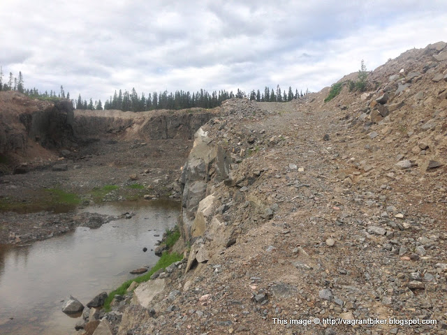
I made camp that night in a dis-used rock quarry; the road getting there wasn't too bad, but taking the service road up the size was sketchy. There was only a two-foot section that I could get through in some areas, and the penalty for getting it wrong was a 30 foot drop to the floor.

But once I was up there, I found it to be open enough that a good breeze kept the bugs down, and then I turned around and saw the view.

 |
 |
| And because I am a grown-up, there was absolutely no peeing off the side of the cliff. Or finding the biggest rocks I could and rolling them off, to watch them shatter when they hit the bottom. No, of course not. I wouldn't do that. It would be silly. |

My lower legs had been sort of itching all day; it hadn't been enough to make me stop and investigate, and with the weather I'd had more pressing things on my mind, but as I undressed in my tent this night I checked them out. The first thing I noticed was the pants on my shins were covered in tiny little dots of dried blood; WTF?


I counted a total of 26 bites of an unknown origin, all confined purely to my shins and calves; nothing was above the knee. And of course now that I saw them, they ALL itched to high heaven, and I think I used half my tube of benzocain to try and get them to shut up so I could sleep this night. How had this happened? Had the B&B that I stayed at had some kind of insect infestation, that managed to get into my boots and bike through my windproof suit liner, and pants? Ugh.

By the next morning they had all swollen up so badly that I had to let my boot straps out another couple of notches just so I could get them fastened, and the itching was even worse. Stupid nature.
Anyway, the weather the next day was even more perfect than the previous evening, and I made good time. It started getting washboarded a bit more the closer I got to Goose Bay, but I could still keep the speed high enough that 5th and 6th gear were usable.

Just before getting to Goose Bay, the Churchill River is traversed via a quarter-mile long bridge. Being this exposed to the wind was sobering, and more than once I almost found myself getting blown into the supports. The wind was whipping up massive dust clouds from the settled silt areas, as well.


I made it into town with less than half a gallon of gas left in the main fuel tank, but make it I did. After getting gas, the first thing I did was check the status of the road; was it open? Had my gamble paid off?

YES! I was victorious! Although the warnings about there being no hotel rooms available anywhere along the route made me chuckle. Bitch, please! I bring my own room!
For as remote of a place as it's in, Goose Bay is a pretty normal looking small town, with one key difference. All of the parking spaces, along every building, has a line of 20a outlets for each space. These are for the vehicle block heaters in the winter; this place gets seriously cold.

 |
| "Yup, skeeter, dat's a bike. Onea dem forgin jobbers, ah reckon!" |
I stopped at a local fried chicken place for some lunch; as ugly as the bike is, it always seems to draw a crowd. Maybe it's the luggage piled on it, or just all the stickers.
I headed out of town after spending a couple hours at the local library, catching up on the Internet. According to the town's website, as well as the guy manning the roadblock, the road was clear all the way past Churchill Falls, a couple hundred miles east. At some point along the way I'd run into the next roadblock, where I'd have to wait for a police escort to take me and the other vehicles through the areas that were either on fire, or very recently on fire.
With good news and good weather, I headed east.


The road between Goose Bay and Churchill Falls is in the process of being paved; some of it is very fresh and I passed a good number of road crews, but large sections of it are still dirt and gravel.

Likely due to the higher traffic volume, this road was MUCH rougher than the long stretched I'd come north on. The washboarding was much more persistent and often there wasn't a single smooth line through, just mile after mile of endless pounding. Even after backing off the rebound damping nearly all the way on the rear shock, it was still starting to pack down at higher speeds. Not fun, and not what I needed with a rear subframe that is still kinda questionable.

The weather was patchy; for the most part it was a 25mph headwind and patchy sun, but occasionally there'd be a spot of rain. Sometimes it looked like the rain was evaporating before it hit the ground.

Just a few miles before I got to Churchill falls, I turned down a little side road that had all sorts of promising warning signs.


The road ended up being both a service path for the water outlet from a hydroelectric setup, but also a recreational boat launch. Most of the industry in this area is either mining, logging, or timber, and randomly in what you thought was a desolate wilderness, you'll come across a giant cable farm.


I followed a little trail off the side road, eventually ending in a couple of sandy clearings. It was a bit too wooded and closed in for my tastes; not much breeze down here and the flies swarmed the second I stopped.


Getting out of the sandy bits was sketchy; I almost spun out a couple times, but it happened too quickly for me to panic and do something dumb like chop the throttle. So rather than to a half turn\slid and drop it, I ended up doing a couple of bad-ass looking 180s that I pretended were completely intentional (even if they pointed me the wrong way.)
Eventually, I made camp higher up the valley, in a clearing with a nice breeze to keep the flies at bay.

With any luck, the next day would see Labrador City, and I could declare victory on the Trans-Lab! (Of course, I had no idea what Quebec had in store for me...)